
Spring snow blankets Oxford
April 23, 2021
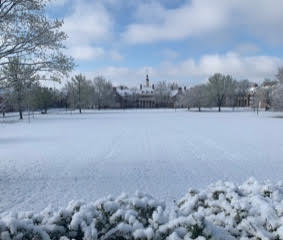
Oxford received about two inches of snow between late Tuesday night and early Wednesday morning. Cars, trees, grassy areas, and elevated surfaces were coated with snow.
Most of the unseasonable snow was gone around noon on Wednesday, but not before more than two dozen Miami students and townspeople responded to Oxford Observer requests to snap some photos before the images all melted away. We present a representative sampling in the attached slide show. Thanks to all who answered our email and Facebook requests.
Although snowfall in late April is rare, it is not unheard of, according to the National Weather Service. A cold low-pressure system can lift and cause snow, which is what occurred earlier this week.
The Cincinnati International Airport received about 2.3 inches of snow. This set a new record for the date, according to the National Weather Service. The old record was 1.5 inches in 1901, according to a tweet from the weather service’s office in Wilmington, Ohio.
Around 3 p.m. Wednesday the weather service issued a freeze warning in preparation of sub-freezing temperatures as low as 26 degrees starting at 1 a.m. and expiring at 10 a.m. Thursday, April 22 for areas of East Central and Southeast Indiana, Northeast and Northern Kentucky, and Central, South Central, Southwest and West Central Ohio.
A freeze watch was also put in effect for late Thursday night into Friday morning for the same regions, due to expected sub-freezing temperatures as low as 30 degrees. While there is no more predicted snow in the forecast, there is a 90% chance of rain on Saturday with a high of 56 degrees.
Now scroll through the pictures and remember, just a couple of days ago, Oxford was covered in snow.